

Echoes from Ancient Amazonia
Archeology in the Amazon is changing our understanding of the past and suggesting new possibilities for the future.


Almost 50 years after Europeans arrived in the Americas, the Dominican friar couldn’t believe his eyes as he and 50 miserable Spanish soldiers floated slowly and quietly east down the Amazon River. From his vessel, Brother Gaspar de Carvajal stared slack-jawed at the riverbank where innumerable indigenous people stared back.
“There was one settlement that stretched for five leagues [12-20 miles] without any intervening space from house to house,” Brother de Carvajal would later write, providing first-hand accounts of an enormous civilization in the continent’s interior, which José Toribio Medina would later recount in The Discovery Of The Amazon: According To The Account Of Friar Gaspar De Carvajal And Other Documents.
After completing the first European journey across South America in 1541-1542, Brother de Carvajal described “great cities” on the riverbank that “glistened in white,” and a land fertile enough to support them. “This land is as good, as fertile, and as normal in appearance as our Spain.”

Nearly 100 years later, the Spanish Jesuit Father Cristóbal de Acuña accompanied a Portuguese expedition up the Amazon River from east to west in 1637-1638. By this time, smallpox had penetrated the interior. Still, the peninsulare would later describe “an infinity of Indians” and settlements along the riverbank that were “so close together, that one is scarcely lost sight of when another comes into view.”
Another 100 years later, French geographer Charles-Marie de la Condamine traveled the river in 1743. This time, he reported no cities and “no warlike tribes inimical to Europeans.” Whoever or whatever was there centuries prior had all but vanished, swallowed by the jungle.
Over time, European historians would neglect the earlier accounts, and lump them in with myths and legends about lost cities of gold in the Amazon like El Dorado. Another 100 years later, by the 19th century, a consensus emerged that no civilizations supported by large-scale agriculture existed in the Amazon basin before Europeans arrived.
“Garden Urbanism”
In front of a computer in France in the 21st century, Professor Stéphen Rostain of the National Centre for Scientific Research may have felt almost as astonished as Brother de Carvajal nearly 500 years ago, as Rostain reviewed aerial renderings of 6,000 rectangular platforms in Ecuador’s Upano valley, connected by wide, straight roads.
Published in 2024 in Science, Rostain’s research documents an “urban network of erected and excavated features,” the largest ever found in Amazonia and comparable in size to the famous Maya complexes in Mexico and Guatemala. It was likely occupied by people from the Kilamope and Upano cultures from about 500 B.C.E. until 300 to 600 C.E. It includes at least 15 interconnected settlements, agricultural terraces, drainage systems, plazas, and defenses.
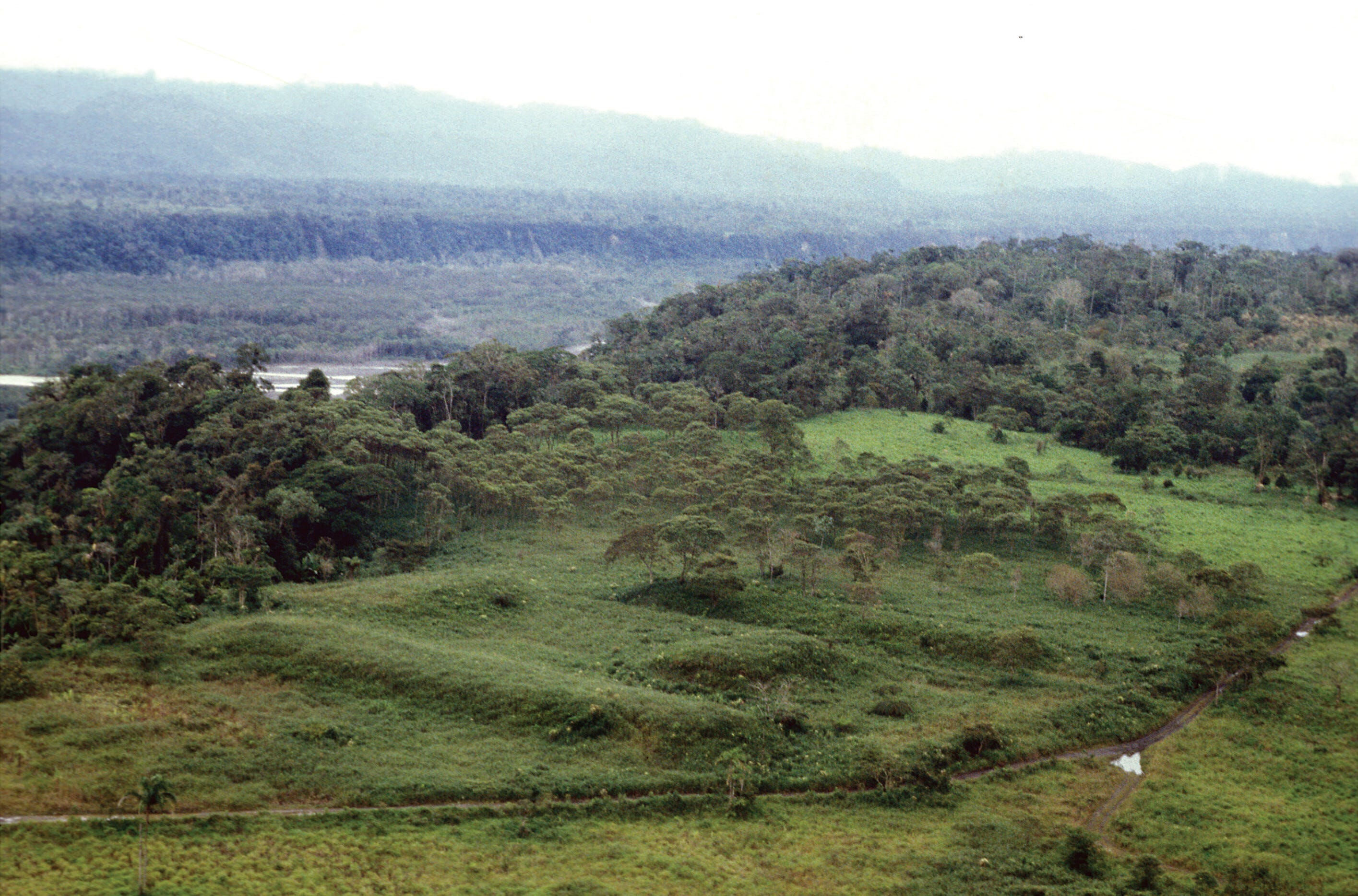
The platforms are grouped into complexes. Each complex is organized around a central plaza, often beside drained fields. The largest complex covers roughly 2.5 acres and includes a monumental platform 460 feet wide, 140 feet long, and nearly 15 feet high. Straight roads cross at right or nearly right angles without deviating for hills or ravines. “The overall organization and standardization of architectural features, the road patterns, or the defense systems, suggests, for instance, the existence of advanced engineering,” Rostain writes: garden urbanism.
The grid-type construction reminds Rostain of the ceque system in Cuzco, Peru, where ritual pathways radiated out from the city’s central temple toward other settlements of the Incan Empire. He stops short of saying the layout is a cosmological design rather than a practical one, but says this is “tempting” to consider.
Visual Echoes
The Upano site is the latest in a string of similar discoveries made over the last 50 years using LiDAR—light detection and ranging technology. Together, they have the power to substantially alter our understanding of history in the Amazon basin, the world’s largest unexplored wilderness.

LiDAR is a remote sensing method used to examine the surface of the Earth. It is like sonar using light instead of sound. An aircraft will direct a grid of infrared light beams at the ground. The beams strike the Earth’s surface and bounce back, providing a measure of distance. It penetrates the dense, monotonous forest canopy to show the contours of the land below.
In remote Amazonia, LiDAR is delivering visual echoes from the past and revealing topographical details archeologists otherwise cannot see. “I have explored the site many times, but lidar gave me another view of the land,” Rostain told Smithsonian Magazine. The LiDAR survey was a capstone on more than two decades of interdisciplinary research at the Upano valley site.
LiDAR revealed Amazonia’s first example of a truly urbanized site at Llanos de Mojos in Bolivia in 2022. Researchers found 26 sites, two large urban centers, monumental platform and conical pyramid construction, raised causeways, a water control and distribution system with reservoirs and canals, artificial terraces, and ceremonial buildings oriented north-northwest.
This likely represents just the tip of the iceberg. One estimate suggests 10,000-24,000 pre-Hispanic earthworks remain hidden across Amazonia.
“We’ve had this western conceit that complex civilizations can’t flourish in the tropics,” Tulane University archeologist Marcello Canuto told National Geographic. Canuto used LiDAR to help reveal the ruins of more than 60,000 previously unknown buildings in the Petén region of Guatemala. “But with the new LiDAR-based evidence from Central America and [Cambodia’s] Angkor Wat, we now have to consider that complex societies may have formed in the tropics and made their way outward from there.”
Diamonds in the Rough
During the late 1970s, flying over Acre State, Brazil in a Smithsonian Institute survey plane, Alceu Ranzi looked down at the devastating effects of deforestation. The lush, living forest would abruptly give way to vast fields clear cut for agriculture. The forest would return, then a field, then the forest, on and on. All of the sudden, leaping up from fields which had supposedly been cleared for the first time in recorded history just a few years prior, enormous geometric shapes revealed themselves one after another, some as large as the bases of pyramids or skyscrapers.
Miles of ancient trenches and hills connect these circles, squares, rectangles, and rhombuses. All of these earthworks are clearly manmade. Ranzi called the formations “geoglyphs.” Like crop circles in England or the Nazca lines in Peru, the geoglyphs are mostly easily perceived from above. Most are circles or squares and measure between 300 and 900 feet in diameter or width.
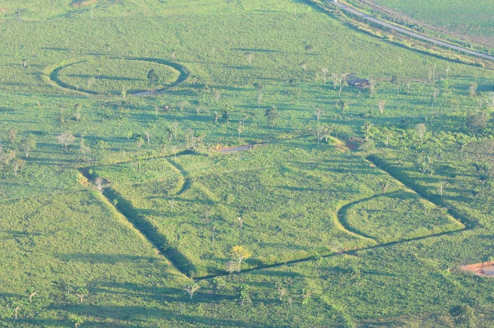
Researchers including Ranzi, Denise Schaan and Martti Parssinen have since identified more than 400 geoglyphs on the interfluvial plateaus of the Acre, Iquiri and Abunã rivers in eastern Acre State, southern Amazonas State, western Rondônia State, and among the lowlands of northeastern Bolivia. The researchers estimate the structures were built 2,000 years ago, while some may have even been built more than 3,000-4,000 years ago. The group concludes the region had less tree cover then, since the geoglyphs could have hardly been constructed let alone seen among dense forests.
Their function is unknown. Built on high ground, they would be poor for drainage. Many have outer walls that look down on the central area, making them poor for defense, too. At most sites, there are no traces of human presence, like ceramics. “The immediate response is that they were symbolic places,” anthropologist Peter Stahl of Binghamton University told Science. “But that’s the old archaeological canard: If you can’t figure out the function of something, you say it was for ritual.”
Terra Preta
These marvelous discoveries refute the Euro-centric consensus that large civilizations supported by agriculture never existed in the Amazon Basin. Now, the question is no longer did they exist, but how.
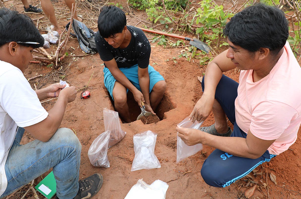
A few years ago Kanu Kuikuro, a village elder among the indigenous Kuikuro people from the Mato Grosso region of Brazil, dug his hands into some of the cool “dark earth” or terra preta in the center of his village, pulling soil samples for a team of researchers from Brazil’s Federal University of Santa Catarina, led by Morgan Schmidt.
The researchers were investigating the patches of dark, fertile soil that dot the Amazon Basin, especially near archeological sites. The terra preta stands out from the red, eroded soil that otherwise dominates the region. It is rich in organic material, like compost, with 10 to 20 to even 45 times more stored carbon than the surrounding soil.
“When you plant where there is no eegepe [dark earth], the soil is weak. That is why we throw the ash, [cassava] peelings, and … pulp,” Kanu Kuikuro said. Villagers heap together waste from fish and cassava, as well as organic ash and charcoal, and the nutrients from this decaying matter seeps into the soil. Afterwards, the soil supports crops that would not thrive in unmodified soil, and the villagers can grow crops in a region that is otherwise not particularly well-suited to agriculture.
This form of bioengineering enables the villagers to produce more crops, and a greater variety of them, on less land. Further, terra preta helps preserve the health of the soil so it can be cultivated more frequently, whereas modern agriculture techniques can deplete and erode topsoil, leaving less land available to cultivate next season.
Archeologists have long suspected indigenous people in the Amazon Basin intentionally created terra preta, an “artificial” topsoil. Now, studies like Schmidt’s, published in 2023, are beginning to lend more credence to this idea. While the study cannot conclusively demonstrate that ancient peoples were making terra preta throughout the Amazon Basin, it does demonstrate that modern indigenous people are doing so in the Upper Xingu region, and that some of the oldest samples of dark earth there are 5,000 years old.
This is the first time scientists have documented the making of dark earth today. “That’s something new as well that nobody’s ever really shown before,” says Schmidt. “The most likely explanation is that they were doing the same things in the past.”
Past is Present
These recent discoveries about ancient Amazonia often raise more questions than answers. Who built all these structures? When? Why? And what do they suggest about Amazonia today? The immediate “takeaway” is not always clear. That is okay.
Fundamentally, the discoveries shed light on patterns of human development. Today, there is a global consensus that our patterns of development—agriculture, city planning, manufacturing—are unsustainable in their current form.
To make our practices more sustainable we often look to digital technology and to the future for answers. Perhaps we are looking in the wrong place at times. Perhaps we should also look to natural technology and to the past.